MAN Wiki
Geology field study (changes)
Showing changes from revision #11 to #12:
Added | Removed | Changed
While field study and field research are distinct terms, they are often used interchangeably in academic contexts, with their specific differences depending on the discipline. In social sciences, for example, “field research” typically involves actively gathering data through methods like interviews, experiments, or questionnaires, whereas “field study” focuses more on observing and documenting phenomena in natural settings.
Introduction of Geology field study
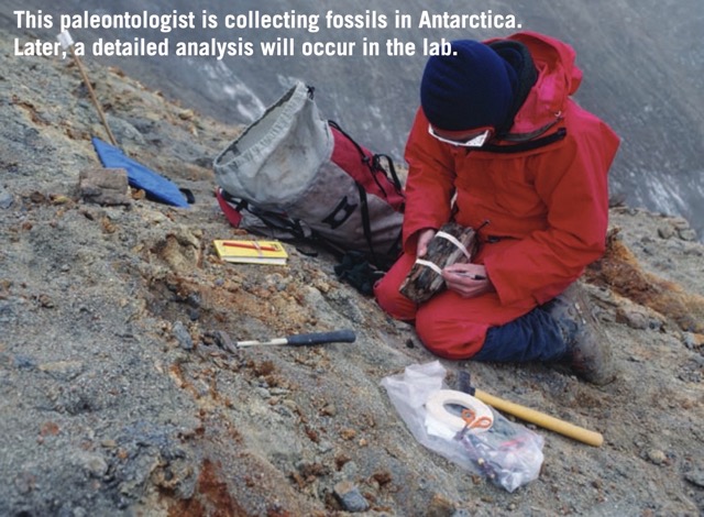
Geology field study, also referred to as fieldwork?. In Geology, a Geology field study generally refers to the process where geologists directly observe, record, and analyze geological features—such as rock outcrops, stratigraphic sequences, structural formations, or fossils — in natural environments. Through systematic mapping, specimen collection, and detailed documentation of these features, geologists reconstruct regional geological histories or develop evolutionary models, ultimately determining the geological history of an area.
Components of Field Studies - Geological instruments
The first component
Topographical maps
The data collected during the field studies, are needed to be documented. The dataare data are plotted on a topographical map, pertaining to the area undertaken for the geological mapping exercise, The topographical maps, therefore constitute the starting point of the field studies, [2]
- Size
One inch = one mile, four miles, eight miles, 16 miles, 32 miles.
One inch = 330 feet, 660 feet, half a furlong, one furlong.
One centimetre = one km.,2,5 km., 2.5 km., 10 km. km, 25 km. km..
One centimetre =100 metres, 200 metres, 500 metres metres.
- Symbols and colors Topographic Map Symbols - USGS Publications Warehouse
Aerial photographs and the satellite imageries
The aerial photographs are similar to the black-white photographs, as far as thetheir the their appearance is concerned. The land surface is photographed from an aeroplane. Depending upon the intensity of the sunlight being reflected, and or refracted by thesurface the surface of the earth (rocks), the tone of the print (the aerial photograph) will vary.

The aerial photographs cover a vast terraine terrain on them, unlike that contained in a topographical map. However, the petrographical and the structural features inferred from the aerial photographs, are required to be confirmed through the routinefield mapping technique.[2][3][4]
The second component
This is a heterogenous component, as it embraces magnetic instrument, lens, chemi.cals, chemicals, and so on. Each one has an important role to play, in collecting data in thefield, the field, and is therefore indispensable. In the following paragraphs a detailed accountof account of the said comnponents, components, has been presented.
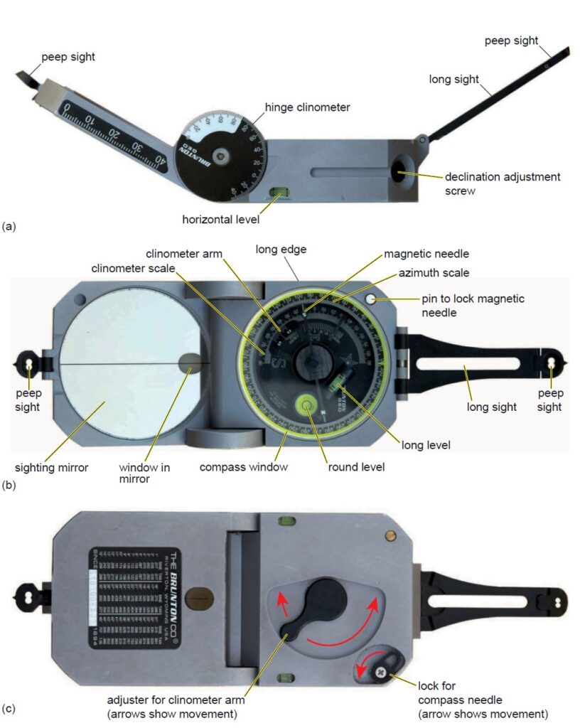
Clinometer compass
This instrument plays a dual role. The first use of it is to take the bearings in the field, in order to locate oneself on the map, during the field work. The second use isto is to measure the amount of dip, the direction of dip, the trend of shears, and theother the other directional structural elements.
A documentation prepared on a paper, with the marking of north line, and a scale, is technically described as a “Map“. The topographical sheets, the geological maps, or any other similar map, therefore bear a north line, as well as a scale. The features like the “hills, the valleys, a temple on hill top, the streams, and so on”, are shown exactly in a way, as they are found to exist with respect to each other on the ground._The geographical positions of the different objects are marked with respect to the NORTH LINE drawn on the map.The distance between the various objects, are monitored by the scale chosen for the map._
How to Use Compass Clinometer1 [5]
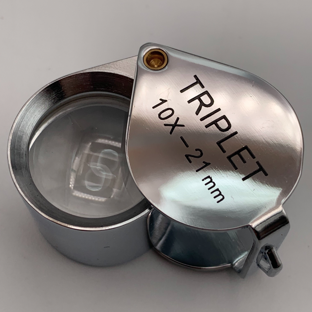
Pocket lens
This usually has a magnification of 10 (ten), and it helps to identify the minerals encountered in the rocks, megascopically i.e., in a hand specimen. Such an identification is fairly accurate. Later on, the identification made in the field, is to beconfirmed be confirmed by the microscopic examination of the thin sections prepared from the rock specimens. At least the commonly and the frequently encountered rock forming minerals, should be identified, while, conducting the field mapping exercise. Unless this is achieved., the distinction between the igneous, the sedimentary and the metamorphic rocks, can not be made during the field studies.
The other components
Penknife HCI acid Sample bags Camera
A penknife is useful in ascertaining whether the ferromagnesian mineral is a mica?. Of course, this is possible, only if, the rock be reasonably coarse grained one. Likewise, the hardness of a mineral could be tested, especially to distinguish a grain of quartz from that of a felspar, or that of a calcite from a grain of felspar. For this purpose too, the rock should be coarse grained one, in order to scratch the grain with a penknife. The streak of the coloured minerals, can be obtained with a penknife. Example is cited of the micaceous hematite, which is also called as the specularite. This mineral being flaky in habit, it might be mistaken for a biotite mica. The bladed form (prismatic habit) also could be mistaken to that of the pyroxenes or the amphiboles. However on scratching such a mineral with a penknife, if “cherry red“ streak be obtained, the identification changes to a micaceous hematite, and not to a biotite mica, or to any ferromagnesian mineral (pyroxene amphibole). However, the use of a penknife requires skill, practice and experience.
Dil. HCl acid is very useful during the programme of field mapping. It is difficult and dangerous te carry it during the actual collection of the rock samples, and the process of mapping in the field, Therefore the suspected carbonate mineral or a rock, can be tested with the dil. HCl acid, after returning to the camp. The carbonate minerals or the rocks are confirmed by treatment with the dil. HCl acid. Calcite gives effervescence, but aragonite (its composition also is CaCO3), does not show any reaction. The role of the dil. HCl acid is especially useful when the matrix of these dimentary rocks, is to be ascertained during the mapping exercise. If the rock gives effervescence, carbonate minerals (calcitel) and not siliceous or argillaceous minerals form the matrix for the grains of the rock.
Sample bags are especially required, if fragile material or fossils, are to be collected. Camera is a very, useful tool, as it faithfully documents the field setting other rocks, special features like the ripples marks, the current bedding, pillow structure, pahoehoe structure, intersecting intrusions (dykes and veins), striations/grooveson the fault planes, and so on, Seeing is believing, and therefore, the field photosmany photos many times provide a critical and an indisputable data, which can be later considered as an evidence. For every field photo taken, the place of the photograph, thedirection the direction of the yiew view of the camera, and other information must be immediatelynoted, immediately noted, right at the site where the photograph is taken.
References
[1] Gokhale, N. W. (2006). A guide to field geology. CBS Publishers & Distributors.
[2] Dury, A., & Andrews, J. (1980). A topographical map of Hartfordshire from an actual survey in which is expressed all the roads, lanes, churches, noblemen and gentlemen’s seats, and every thing remarkable in the county. Hertfordshire Publications. (Original work published 1766)
[3] OpenStreetMap. (n.d.). Retrieved [date you accessed the site], from https://wiki.openstreetmap.org/
[4] American Association of Petroleum Geologists. (n.d.). Geologic mapping. Retrieved [date you accessed the site], from https://wiki.aapg.org/Geologic_mapping
[5] Geology In. (n.d.). How to use compass clinometer. Retrieved [date you accessed the site], from https://www.geologyin.com